Datasets:

The dataset viewer is not available for this dataset.
Error code:   ConfigNamesError
Exception:    RuntimeError
Message:      Dataset scripts are no longer supported, but found plantations_segmentation.py
Traceback:    Traceback (most recent call last):
                File "/src/services/worker/src/worker/job_runners/dataset/config_names.py", line 66, in compute_config_names_response
                  config_names = get_dataset_config_names(
                File "/src/services/worker/.venv/lib/python3.9/site-packages/datasets/inspect.py", line 161, in get_dataset_config_names
                  dataset_module = dataset_module_factory(
                File "/src/services/worker/.venv/lib/python3.9/site-packages/datasets/load.py", line 1031, in dataset_module_factory
                  raise e1 from None
                File "/src/services/worker/.venv/lib/python3.9/site-packages/datasets/load.py", line 989, in dataset_module_factory
                  raise RuntimeError(f"Dataset scripts are no longer supported, but found {filename}")
              RuntimeError: Dataset scripts are no longer supported, but found plantations_segmentation.py
Need help to make the dataset viewer work? Make sure to review how to configure the dataset viewer, and open a discussion for direct support.
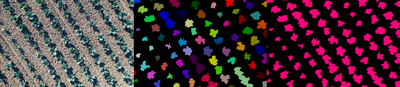
Plantations Segmentation Object Detection dataset
The dataset consist of aerial photography of agricultural plantations with crops such as cabbage and zucchini. The dataset addresses agricultural tasks such as plant detection and counting, health assessment, and irrigation planning.
💴 For Commercial Usage: To discuss your requirements, learn about the price and buy the dataset, leave a request on our website to buy the dataset
Dataset structure
- Plantations_Segmentation - contains of original plantation images (folder img) and file with annotations (.xml)
- Object_Segmentation - includes object segmentation masks for the original images
- Class_Segmentation - includes class segmentation masks for the original images
Types of segmentation
The dataset includes two types of segmentation:
- Class Segmentation - objects corresponding to one class are identified
- Object Segmentation - all objects are identified separately
Data Format
Each image from img folder is accompanied by an XML-annotation in the annotations.xml file indicating the coordinates of the polygons. For each point, the x and y coordinates are provided.
Example of XML file structure
.png?generation=1686129907313187&alt=media)
Plantation segmentation might be made in accordance with your requirements.
💴 Buy the Dataset: This is just an example of the data. Leave a request on our website to discuss your requirements, learn about the price and buy the dataset
Leave a request on our website to discuss your requirements, learn about the price and buy the dataset.
Our Team
keywords: agricultural tasks dataset, image segmentation dataset, plantations images dataset, plantations segmentation dataset, land cover dataset, agricultural products dataset, semantic segmentation dataset, agriculture dataset, agricultural data, object detection dataset, plants segmentation dataset, plant detection, plant recognition
- Downloads last month
- 142